This oddly named trail in South Cumberland State Park, Tennessee tops my very competitive list of Southeastern US hikes. The Fiery Gizzard is even a part of the top 25 US hikes according to Backpacker Magazine! You’ll quickly see why it’s so loved but you’ll also see why some are quick to curse its name.
It’s a beautifully diverse trail filled with waterfalls, ancient cave shelters, swimming holes, towering rock formations and panoramic views. What makes it difficult is the arduous descent and ascent in and out of the rocky gorge. If you don’t wish to negotiate loose rock for 5 miles you can bypass the gorge by taking the Dog Hole Trail. We opted for taking on the gorge in what ended up being a 15 mile one-way hike starting from the Grundy Forest State Natural Area. At the time there was only one backcountry camping area located around mile 10. To stay you needed a permit from TNstateparks for $8/night. It was nice to be picking up 2 permits after recently taking a few solo trips! A lifelong friend who rarely hiked decided to join me. I was confident he’d enjoy it being a long distance runner and I think he did outside of losing both big toe nails… Buy good socks and boots people!

The trail starts by passing a 500 year old Hemlock tree and after only a half mile you’ll stumble upon the ginormous Blue Hole Falls (above). Around every corner seemed to be some major point of interest. Next up was a feature named Black Canyon where Little and Big Fiery Gizzard Creeks merge and create a wicked looking cascade.

Soon thereafter we came across a superb swimming hole and Sycamore Falls. A few teenagers were hanging out and jumping off rocks into the water but we decided to just take a few pictures and carry on. We didn’t want to get wet which makes me laugh to write as you’ll soon see why.

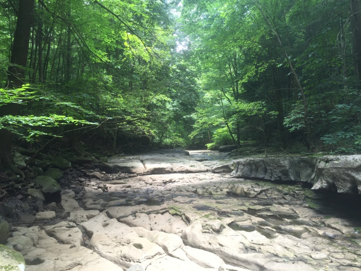
For the next 2 miles we hiked down into the canyon and along the canyon floor with most of the trail looking like the below picture.

Along the canyon floor there are over 600 types of plants growing and all of them seem to be vibrant and green. Some names crack me up like the dwarf crested iris, reindeer moss and especially the beefsteak fungus.

Someone’s looking tired but still ready to lead the charge! Before climbing back up to the canyon rim we crossed over a dried out river and witnessed many other oddities that were all really intriguing.
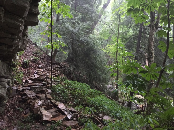
Getting back to the rim is the most strenuous section of the hike and the picture below was that terrain at its easiest. We were too exhausted to take a lot of pictures even though we were probably stopping every minute.

Just before making it to the top we took a .4 mile spur trail that lead to the spectacular Raven Point Overlook.

Could there be a place to take a break and have lunch? I don’t think so.

As we were basking in the glory of finishing the hardest section of the Fiery Gizzard we noticed the rain coming down in the distance like you can see below. It seemed to be getting closer by the second and within a quarter mile of leaving Raven Point it started to downpour. We were joking early about getting monsooned on while hiking in the North Georgia Mountains last year but the word monsoon took on a new meaning.

We were drenched quickly. Luckily the rest of the trail follows the top of the Cumberland Plateau with the exception of one more precarious half mile section that dips into Laurel Branch Gorge across myriad rocks that all seem to move as you step on them. That was certainly difficult during the rain but we found a good hiding spot near the tail end of the storm.
We didn’t stay long as by that point everything we had and were wearing was completely soaked through. It’s safe to say we learned some valuable lessons about gear and gear storage. It finally made sense why people wear gaiters and I really wanted to upgrade my sleeping pad as the one I had prevented my pack from being fully covered which made my sleeping bag and spare clothes wet. I could have also put everything in a trash bag or dry sac which are 2 things I now never camp without.

Once the rain subsided everything became so mysteriously awesome. We may have been sloshing around in pools of water but we had big smiles on our faces!

That had a lot to due with the amazing views into the fog filled canyon like below. It almost felt like we were transported to a completely different trail in a land far away.

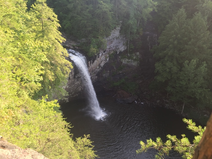
Of course we passed a few more waterfalls like the one below.

Right after getting back to the canyon rim after taking a dip into the Laurel Branch Gorge we set up home in the designated small wild camping area.

What made this area extra special was having a beautiful overlook close by.

Here we enjoyed dinner then watched the fog roll in until we became completely consumed by it.


I love the fog and at night it makes everything so eerie and cool. The use of headlamps only makes visibility worse so trying to navigate really forces you to be patient and enjoy the dark unknown. We did eventually find our tent and slept soundly. We rose early to enjoy the morning light in our soaked through wardrobe and were able to keep up the tradition of eating our meals at overlooks.

2 miles later we stared in amazement at the final and most stunning waterfall, the 60′ Foster Falls. The vibrate colors of the trees made this the perfect ending to a wonderful hike. If you are ever in the area Foster Falls is worth a pit stop on its own. After another mile we finished the hike but then came the task of getting back to the car. I was praying what I read was true about a man who lived in the nearby Tracy City who would provide a taxi service for $10. It said there would be a sheet of paper near the restrooms with his info and thankfully there was. It was pretty early but he answered the phone, picked us up and dropped us off with no problem! Shout out to Tim or whatever that guy’s name was.
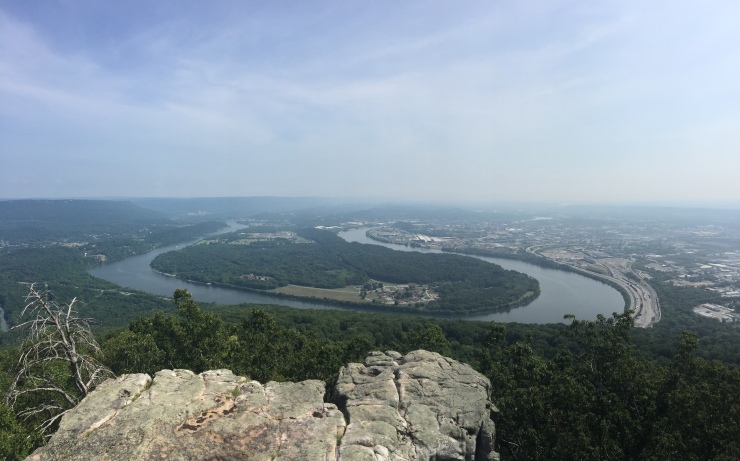
On the 2hr 30min drive back to Atlanta we stopped at Chickamauga & Chattanooga National Military Park to make use of my America the Beautiful pass. Here on Lookout Mountain you’ll have a sweeping view of the Tennessee River as it bends around Chattanooga.
If you live remotely close to Chattanooga get your butt up to the Fiery Gizzard Trail. It’s a perfect backpack!

These are awesome – keep em coming. What a damn hike!
LikeLike
Photos are great! Lots of good advice. These just keep getting better and better.
LikeLike
Awesome!
LikeLike